Sunday, October 28, 2012

Day 45 ...and long walks on the beach

How long is a long walk on the beach?  I've been going well over 200 kms on the beach since leaving Valparaiso six days ago, sometimes in the lapping surf, sometimes among the dunes, sometimes arriba over the rocky cliffs... the noisy sea lions, squawky pelicans, flitting and chatty oystercatchers and clamdiggers keeping me fine company, along with a few surferboys owning the enormous waves.  The weather's been perfect for this long walk on the beach with constant cloudcover keeping the sun off my face for the time being allowing my nose and cheeks to peel back to the standard pink.  (Little kids still point and cry out "Mama, mira! una rubia!")

I made a command decision this morning to continue along the coast as the desert begins to overtake the verdant vegetation of the south.  I chose against an interior route that's just as deserty and away from the coolness of the coastal winds but that has more villages for nighttime support.  The coast, which I always adore, has very few villages and uncomfortably widely spaced.  I'll be picking up speed a bit.  Heading now for La Serena, dating from 1544, it's the first town settled by the Spaniards - 13 years after the apparitions of Our Lady of Guadalupe in Mexico.

No one's asked to take photos with me lately, so no updates there... I'll find opportunitites to ask.
Happy Halloween!

Tuesday, October 23, 2012

Day 40 Bread and Water

An odd clash of cultures, a pilgrimage and Chilean meals.  Breakfast here is leaner than even in Italy - a piece of toast and a cup of coffee, then I'm off for mountainous trekking.  The main meal of the day is eaten around 2 in the afternoon, when I'm walking.  Finally at 9 or 10 in the evening, a cup of coffee and some bread with margarine and jam.  The timetables of daily meals has been out of alignment lately, and I've gone three days now on bread and a few cups of coffee.  Walking through the vineyards, I've only been offered water to drink during the day.  Not one to complain, I explained this predicament to today's parish priest when he asked if there was anything I need, and he's now preparing a proper dinner.

I've reached the South Pacific and dipped my toe in to christen the event.  Some boys were swimming in the crystalline blue surf, loads of people on the beach... the water is certainly inviting, though too cold in this early springtime for full immersion in my opinion.

The mountains plunge right into the sea and the walk involves many big ups and equally many big downs.  Santiago was as far south as the pilgrim route goes, and I'm heading north again, directly into the sun, giving the burn on my face a chance to even out after the month plus of walking west and only over-weathering the right side.  It takes some work trying to figure out the daily routes now; the towns are becoming more widely separated with fewer roads connecting them.  The Atacama Desert is the next big destination, and then the effort to cross it with the stipulations that I don't like walking alongside the highways and I have to find a house or other building to sleep in every 45 to 55 kilometers.  Still hoping to reach Cuzco for Christmas.

Pilgriming remains great!

Monday, October 15, 2012

Day 32 Over the Top

Two significant changes happened as I crossed a flowing river out of the pampas into the province of Mendoza.  First, gone the corn and wheat in the irrigated farmland, replaced by vineyards as far as the eye can see.  Second, it rained.  For three days the rain came down cold and harsh from a low grey ceiling that prevented me from seeing the approaching Andes.  By the time the clouds lifted, I was already stepping into the mountains.  Quite a shame, missing the appearance of Aconcagua, the highest mountain in the Americas at 22,800 feet, over the horizon.

Still following the old Caminos Reales, the hike up up up from 2,500 feet in Mendoza to the pass at 12,500 feet, was used throughout history by anyone wishing to cross the Andes.  Informative historical markers point out Inca ruins in many places.  Treeless and all but barren, the snowcapped peaks on either side of the Mendoza River stand out majestically - many are more than 20,000 feet high.  Tall.  A huge engineering feat, a railroad was built more than a century ago with support towns established every 30 kms or so, linking the east and west coasts of the continent.  For reasons no one seems to know, it was abandoned in the mid 1990s and the towns now complete ghost towns or inhabited by a few old timers who have no where else to go.  The land can't seem to support even a few cows.  Without the railroad, it's a hard life.  A few ski lifts dot the upper parts of the valley, but they're hardly resorts.

With many adventures - one in which I became separated from my second pair of socks - I reached the continental divide four days out of Mendoza, the last day with the greatest elevation gain and the greatest temperature drop.  I love the cold temperatures - wearing everything except my summer hiking skort and pajama top, and carrying very little.  I could do without the fierce and frigid headwind.  (Always optimistic, when it's so windy, at least I can pee standing up.)

When I arrived at Las Cuevas, the last hamlet before the continental divide, late in the afternoon, I asked for advice on how to proceed over the top... 8 kms of switchbacks gaining 5,000 feet in elevation, and at that moment, clouds forming over the razoredge ridge and snow blowing in the persistant frigid wind... 'come back in December' was the consensus if I intended to go by foot.  The alternative is the 3-km-long tunnel into Chile... no one, it seems, ever just walks into Chile.  Hoping the snow wouldn't accumulate overnight, I slept snuggly in a stone lodge under half a dozen wool blankets in front of a tiny space heater.  The morning was clear as could be yet looking up from below, the 'white wind' was blowing relentlessly over the ridge.  A degree or two above freezing is fine, but accompanied by a 60 mph wind... less appealing.  Nonetheless, I headed up the trail toward the statue of Cristo Redentor marking the peaceful border.  With great effort, I got to within a kilometer of distance and a few hundred feet of elevation before the whiteout conditions forced me to abandon the effort of walking into Chile.  Rats.  Had I a companion who knew the route, or at least some crampons... Quite a similar experience to crossing the Alps on the Via Francigena six years ago on my first pilgrimage.  I had to abandon the effort, retrace my steps, and get a ride through the tunnel.  On the Chilean side, it was clear that I never would have been able to make it down the windward trail for all the snow.  Ah well.  I tried and had a great time.

Down down down, I've reached the first village in Chile.  Much greener on this side of the mountains, the surrounding peaks rugged and inviting rather than barren and stark.  The river coming down from the glaciers along the divide runs clear rather than red from the burden of the eroded rocks on the Argentina side.  A few more days and I'll reach Santiago, then Valparaiso, and then figure out the strategy for crossing the great Atacama desert.
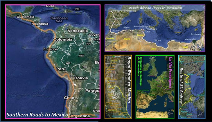
Saturday, October 6, 2012

Day 24 Holy Thermal Baths, Batman!

Some days are long; some days are short.  It all depends on where the villages are.  After lumbering over 130 kms in 3 days, I passed to the south of the sole breaching whale of a mountain and found the active city of San Luis.  Though hoping would see more mountains beyond the mountain, I only discovered more endless views of flatland.  The welcomed difference is the dryness - more deserty vegetation, scrubby trees and cactus instead of lush prairie grasses and fallow farm fields, and most delightfully, no more mosquitos.  Anyone following my tracks would note the sudden interruption of the steady line of dead mosquitos I left in my trail.

The additional sudden change is the lack of population.  Hamlets are few and far between.  I still follow the old Camino Real, but sometimes with 25 kilometers or more between houses and drinking water.  A few scraggly cows and horses keep me company; the guinea pigs have been replaced by lizards scurrying beneath the underbrush.  Endless chatty birds.

Continuing along with the crappy map of Argentina, one dot looks like the next, though the legend says 0 to 1,000 inhabitants... in most cases, the population of the dot is on the 0 end of the scale.  Ghost towns around old railroad stations.  In San Luis, a provincial city of a few hundred thousand, an energetic parish priest insisted that I stop the next night in a village with another one of his 5 churches.  I was reluctant, being only 30 kilometers away, until he mentioned the thermal waters there.  Hard to find sweeter words to fill the ears of a pilgrim.  And me, a VIP (verily intrepid pilgrim?), had a long hot soak for my feet and the rest of me, sunburnt arms and all... it's great when these little gems reveal themselves, like cherries popping up right in front of you and getting surprise bonus points in the Super Mario Brothers game of life =)

Tuesday, October 2, 2012

Day 19 Some Relief

Nineteen days and close to 800 kms (500+ miles) into the pilgrimage - a distance greater than the Camino Frances to Santiago de Compostela - and finally, far ahead of me, some topographic relief.  A distant blue mountain rising above the horizon like a sole breaching whale.  The terrain is still rather flat, but not so much like Kansas anymore... small rises of prairieland, sand dunes covered with grasses and thorny shrubs, allow occasional glimpses of what's to come.

I'm still able to follow the old railroad beds on small dirt roads or grassy paths alongside.  I've seen some graceful big felines - pumas they tell me, but I think it's more of a generic name than species; these are fluffy and pale yellow - but mostly guinea pigs and armadillos on the ground and an abundance of noisy birds in the sky and treetops.

The tranquility increases as I head westward.  The number of villages has decreased significantly and I only see a few people during the day's walk.  It's interesting to note the vocabulary... when I ask how far to the next village (and these are villages of a few dozen to a few hundred inhabitants), the answer from the old men of the ranches is generally given in leagues.  A league is the distance that can be walked in an hour.  This used to be a standard unit of measure in all European countries - so much so that it's the same word in many languages - until people switched over to cars.  It's amusing to hear the old men speak of leagues while the young people (including me!) use kilometers.

Pilgrim duties along any off-the-beaten-track camino include the interviews.  Already, I was interviewed for a local paper Vadia, did a television interview in a town called General LaValle, and an interview during a live radio program in Vicuña MacKenna.  What is a pilgrim doing here???  As unnerving as it might be for those moments when my slowly improving Spanish mustn't fail, it's a fun part of the pilgrim experience telling people why there villages are important.  I'm following, after all, a Camino Real, where the Spanish colonists marked out their new world, rightly or wrongly, a part of history.  I've seen a few references to the Camino Real - old wayside inns - but because the current population is largely made up of second and third generation Italians, Irish, and Germans, the history is all but lost.  Another reason pilgrims are important.

A purpose of following this route to the Basilica of Guadalupe in Mexico was to see if the tradition of Guadalupe is known in these distant parts of the Americas.  Yes, indeed, it is.  I pass Iglesias and Capillas de Nuestra Señora de Guadalupe every day, and nearly every church and many private homes I've entered have the image hanging in prime spots.  To be a pilgrim to the Basilica in Mexico is to be welcomed everywhere.  The downside is, as is so often, having to carry so much food everyone insists on giving me - kilos of fruit, salami, and cheese.  Pilgrim life's not so bad!